If you aren't familiar with the app, here are the steps to make your life so much easier while traveling using public transportation.
First, download the app. Its available on android, iOS, and web. I use it on my iPad and iPhone.
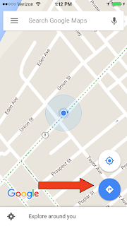
Touch the blue circle with the arrow in it.

It will bring you to the directions page. Select the train image then type in your destination. You can use the address, but I usually type in the name of the place. Google is very smart.
It will give you route options and length of trip to choose from.

Once selected it gives you directions, including walking to your destination.

If it doesn't have an option for public transportation, it will give you a quote for how much it will cost you to take an Uber.
I don't have data available in other countries, so I use it while I'm on wifi, screen shot it and follow the route. Google Maps will download the city you are in while you are on wifi, just open google maps and your GPS in the phone will move the blue dot around to show you where you are on the map.
Good luck circling the world!
No comments:
Post a Comment